Search Product
Our Categories
Your Cart
Your order qualifies for free shipping!
Your shopping bag is currently empty
Continue Shopping
God Particle Wargaming Mat on Sale
Original price was: $54.95.$27.48Current price is: $27.48.
Pleasant Surprise Spacebar Keycap For Discount
Original price was: $9.95.$4.98Current price is: $4.98.


God Particle Extended Mousepad Online Hot Sale
Original price was: $36.95.$18.48Current price is: $18.48.
Home Sweet Home Day Tote Online now
Original price was: $22.95.$11.48Current price is: $11.48.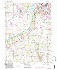
~ Trenton OH topo map, 1:24000 scale, 7.5 X 7.5 Minute, Historical, 1966, updated 1988 For Cheap
Original price was: $24.95.$12.48Current price is: $12.48.
Recently Viewed
~ Amory SE MS topo map, 1:24000 scale, 7.5 X 7.5 Minute, Historical, 1966, updated 1981 Cheap
Original price was: $14.95.$7.48Current price is: $7.48.

Shiba Shiba Shiba! Pattern Gradient Edition Wargaming Mat Bag Sale
Original price was: $22.95.$11.48Current price is: $11.48.
~ Isaac Meadows MT topo map, 1:24000 scale, 7.5 X 7.5 Minute, Historical, 1966, updated 1970 Online Hot Sale
Original price was: $14.95.$7.48Current price is: $7.48.
Old English Sheepdog Spring Path Pair of Pot Holders Online Sale
Original price was: $19.99.$10.00Current price is: $10.00.Description
Trenton, Ohio, USGS topographic map dated 1966.
Includes geographic coordinates (latitude and longitude). This topographic map is suitable for hiking, camping, and exploring, or framing it as a wall map.
Printed on-demand using high resolution imagery, on heavy weight and acid free paper, or alternatively on a variety of synthetic materials.
Topos available on paper, Waterproof, Poly, or Tyvek. Usually shipping rolled, unless combined with other folded maps in one order.
- Product Number: USGS-5319886
- Free digital map download (high-resolution, GeoPDF): Trenton, Ohio (file size: 11 MB)
- Map Size: please refer to the dimensions of the GeoPDF map above
- Weight (paper map): ca. 55 grams
- Map Type: POD USGS Topographic Map
- Map Series: HTMC
- Map Verison: Historical
- Cell ID: 45618
- Scan ID: 228231
- Imprint Year: 1988
- Woodland Tint: Yes
- Visual Version Number: 1
- Photo Revision Year: 1987
- Aerial Photo Year: 1984
- Edit Year: 1987
- Field Check Year: 1955
- Datum: NAD27
- Map Projection: Polyconic
- Map published by United States Geological Survey
- Map published by: Military, Other
- Map Language: English
- Scanner Resolution: 600 dpi
- Map Cell Name: Trenton
- Grid size: 7.5 X 7.5 Minute
- Date on map: 1966
- Map Scale: 1:24000
- Geographical region: Ohio, United States
- Map Area ID: AREA39.539.375-84.5-84.375
- Northwest corner Lat Long code: USGSNW39.5-84.5
- Northeast corner Lat Long code: USGSNE39.5-84.375
- Southwest corner Lat Long code: USGSSW39.375-84.5
- Southeast corner Lat Long code: USGSSE39.375-84.375
- Northern map edge Latitude: 39.5
- Southern map edge Latitude: 39.375
- Western map edge Longitude: -84.5
- Eastern map edge Longitude: -84.375
-
Neighboring Maps:
Northwest North Northeast West MAP East Southwest South Southeast All neighboring USGS topo maps are available for sale online at a variety of scales.
Spatial coverage:
Topo map Trenton, Ohio, covers the geographical area associated the following places:
– Green Acres – Excello – Woodsdale Park – Bon Veue – Trenton – Maustown – Princeton – Kyles – Snow Hill – Liberty Trails – North Excello – Hunting Creek Estates – Country Club Highlands – Linn-Crest Acres – Greenlawn – Hughes – Le Sourdsville – Rockdale – Brookview – Busenbark – South Middletown – Greystone – Country View Estates – Huntsville – Dutchland Woods – Arbor Crest – Oneida – Woodsdale – Brofield Estates – South Excello
Additional information
Print Material Regular Paper, Waterproof, Polypropylene, Tyvek
Related products
50%
~ Sussex VA topo map, 1:24000 scale, 7.5 X 7.5 Minute, Historical, 1967, updated 1990 Discount
Original price was: $14.95.$7.48Current price is: $7.48.50%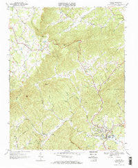
~ Stuart VA topo map, 1:24000 scale, 7.5 X 7.5 Minute, Historical, 1967, updated 1971 Hot on Sale
Original price was: $14.95.$7.48Current price is: $7.48.50%
~ Whaleyville VA topo map, 1:24000 scale, 7.5 X 7.5 Minute, Historical, 1967, updated 1981 Supply
Original price was: $14.95.$7.48Current price is: $7.48.50%
~ Smith Mountain Dam VA topo map, 1:24000 scale, 7.5 X 7.5 Minute, Historical, 1967, updated 1984 Online Sale
Original price was: $14.95.$7.48Current price is: $7.48.50%
~ Tenth Legion VA topo map, 1:24000 scale, 7.5 X 7.5 Minute, Historical, 1967, updated 1970 For Discount
Original price was: $14.95.$7.48Current price is: $7.48.50%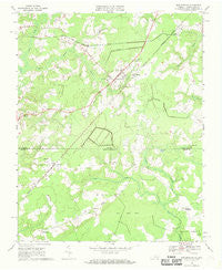
~ Whaleyville VA topo map, 1:24000 scale, 7.5 X 7.5 Minute, Historical, 1967, updated 1969 Discount
Original price was: $14.95.$7.48Current price is: $7.48.
~ Trenton OH topo map, 1:24000 scale, 7.5 X 7.5 Minute, Historical, 1966, updated 1988 For Cheap
Original price was: $24.95.$12.48Current price is: $12.48.