Search Product
Our Categories
Your Cart
Your order qualifies for free shipping!
Your shopping bag is currently empty
Continue Shopping
God Particle Wargaming Mat on Sale
Original price was: $54.95.$27.48Current price is: $27.48.
Pleasant Surprise Spacebar Keycap For Discount
Original price was: $9.95.$4.98Current price is: $4.98.


God Particle Extended Mousepad Online Hot Sale
Original price was: $36.95.$18.48Current price is: $18.48.
Home Sweet Home Day Tote Online now
Original price was: $22.95.$11.48Current price is: $11.48.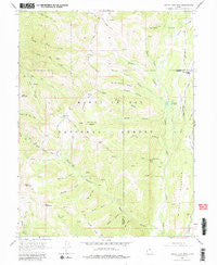
~ South Tent Mountain UT topo map, 1:24000 scale, 7.5 X 7.5 Minute, Historical, 1966, updated 1980 Sale
Original price was: $14.95.$7.48Current price is: $7.48.
Recently Viewed

Donskoy Don Sphynx Cat in Fall Leaves Greeting Cards Pack of 8 For Discount
Original price was: $14.99.$7.50Current price is: $7.50.
Quiet Solitude Mousepad For Discount
Original price was: $15.99.$8.00Current price is: $8.00.
Mixed Fruits and Vegetables Greeting Cards Pack of 8 Online
Original price was: $14.99.$7.50Current price is: $7.50.
Malayan Cat By the Christmas Tree Greeting Cards Pack of 8 For Discount
Original price was: $14.99.$7.50Current price is: $7.50.Description
South Tent Mountain, Utah, USGS topographic map dated 1966.
Includes geographic coordinates (latitude and longitude). This topographic map is suitable for hiking, camping, and exploring, or framing it as a wall map.
Printed on-demand using high resolution imagery, on heavy weight and acid free paper, or alternatively on a variety of synthetic materials.
Topos available on paper, Waterproof, Poly, or Tyvek. Usually shipping rolled, unless combined with other folded maps in one order.
- Product Number: USGS-5460917
- Free digital map download (high-resolution, GeoPDF): South Tent Mountain, Utah (file size: 12 MB)
- Map Size: please refer to the dimensions of the GeoPDF map above
- Weight (paper map): ca. 55 grams
- Map Type: POD USGS Topographic Map
- Map Series: HTMC
- Map Verison: Historical
- Cell ID: 42302
- Scan ID: 251984
- Imprint Year: 1980
- Woodland Tint: Yes
- Aerial Photo Year: 1963
- Field Check Year: 1966
- Datum: NAD27
- Map Projection: Polyconic
- Map published by United States Geological Survey
- Map Language: English
- Scanner Resolution: 600 dpi
- Map Cell Name: South Tent Mountain
- Grid size: 7.5 X 7.5 Minute
- Date on map: 1966
- Map Scale: 1:24000
- Geographical region: Utah, United States
- Map Area ID: AREA39.539.375-111.375-111.25
- Northwest corner Lat Long code: USGSNW39.5-111.375
- Northeast corner Lat Long code: USGSNE39.5-111.25
- Southwest corner Lat Long code: USGSSW39.375-111.375
- Southeast corner Lat Long code: USGSSE39.375-111.25
- Northern map edge Latitude: 39.5
- Southern map edge Latitude: 39.375
- Western map edge Longitude: -111.375
- Eastern map edge Longitude: -111.25
-
Neighboring Maps:
Northwest North Northeast West MAP East Southwest South Southeast All neighboring USGS topo maps are available for sale online at a variety of scales.
Spatial coverage:
Topo map South Tent Mountain, Utah, covers the geographical area associated the following places:
– Bulger Canyon – Manti National Forest – Cow Fork – Spring City Tunnel – Sheep Flat – Black Canyon – South Tent Mountain – Lost Basin – Little Mountain – Potters Canyon Ditch – Becks Cabin – Potters Ponds – Soren Peterson Meadow – Mountain Tunnel – North Tent Mountain – Spring City Ditch – Little Buck Basin – Potters Canyon – Mountain Tunnel Ditch – Bulger Ridge – Bennetts Canyon – Meadow Fork – Brough Fork – Dry Canyon – Fly Canyon – Hogan Basin – Potters Pond Number One Dam – Lowry Top – Browns Canyon – Cedar Creek Tunnel – Bacon Rind Ridge – Black Canyon – Red Pine Cove – Mill Canyon – Bacon Rind Canyon – Buck Basin – Booths Canyon – Potters Pond Number Two Dam – Scad Valley Divide – Middle Mountain – Elizas Fork
Additional information
Print Material Regular Paper, Waterproof, Polypropylene, Tyvek
Related products
50%
~ Stony Creek VA topo map, 1:24000 scale, 7.5 X 7.5 Minute, Historical, 1967, updated 1983 on Sale
Original price was: $14.95.$7.48Current price is: $7.48.50%
~ Stanley VA topo map, 1:24000 scale, 7.5 X 7.5 Minute, Historical, 1967, updated 1987 Fashion
Original price was: $14.95.$7.48Current price is: $7.48.50%
~ Smith Mountain Dam VA topo map, 1:24000 scale, 7.5 X 7.5 Minute, Historical, 1967, updated 1984 Online Sale
Original price was: $14.95.$7.48Current price is: $7.48.50%
~ Sussex VA topo map, 1:24000 scale, 7.5 X 7.5 Minute, Historical, 1967, updated 1990 Discount
Original price was: $14.95.$7.48Current price is: $7.48.50%
~ Whaleyville VA topo map, 1:24000 scale, 7.5 X 7.5 Minute, Historical, 1967, updated 1981 Hot on Sale
Original price was: $14.95.$7.48Current price is: $7.48.50%
~ Sussex VA topo map, 1:24000 scale, 7.5 X 7.5 Minute, Historical, 1967, updated 1990 Discount
Original price was: $14.95.$7.48Current price is: $7.48.
~ South Tent Mountain UT topo map, 1:24000 scale, 7.5 X 7.5 Minute, Historical, 1966, updated 1980 Sale
Original price was: $14.95.$7.48Current price is: $7.48.