Search Product
Our Categories
Your Cart
Your order qualifies for free shipping!
Your shopping bag is currently empty
Continue Shopping
God Particle Wargaming Mat on Sale
Original price was: $54.95.$27.48Current price is: $27.48.
Pleasant Surprise Spacebar Keycap For Discount
Original price was: $9.95.$4.98Current price is: $4.98.


God Particle Extended Mousepad Online Hot Sale
Original price was: $36.95.$18.48Current price is: $18.48.
Home Sweet Home Day Tote Online now
Original price was: $22.95.$11.48Current price is: $11.48.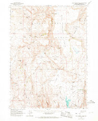
~ Rock Spring Table NV topo map, 1:62500 scale, 15 X 15 Minute, Historical, 1965, updated 1968 Sale
Original price was: $14.95.$7.48Current price is: $7.48.
Recently Viewed

~ Newcomb SE NM topo map, 1:24000 scale, 7.5 X 7.5 Minute, Historical, 1966, updated 1969 For Cheap
Original price was: $14.95.$7.48Current price is: $7.48.
Bite Me Alligator Doormat Cheap
Original price was: $24.99.$12.50Current price is: $12.50.
~ Meadow Grounds PA topo map, 1:24000 scale, 7.5 X 7.5 Minute, Historical, 1967, updated 1984 Online
Original price was: $14.95.$7.48Current price is: $7.48.Description
Rock Spring Table, Nevada, USGS topographic map dated 1965.
Includes geographic coordinates (latitude and longitude). This topographic map is suitable for hiking, camping, and exploring, or framing it as a wall map.
Printed on-demand using high resolution imagery, on heavy weight and acid free paper, or alternatively on a variety of synthetic materials.
Topos available on paper, Waterproof, Poly, or Tyvek. Usually shipping rolled, unless combined with other folded maps in one order.
- Product Number: USGS-5573098
- Free digital map download (high-resolution, GeoPDF): Rock Spring Table, Nevada (file size: 7 MB)
- Map Size: please refer to the dimensions of the GeoPDF map above
- Weight (paper map): ca. 55 grams
- Map Type: POD USGS Topographic Map
- Map Series: HTMC
- Map Verison: Historical
- Cell ID: 61680
- Scan ID: 321251
- Imprint Year: 1968
- Woodland Tint: Yes
- Aerial Photo Year: 1963
- Field Check Year: 1965
- Datum: NAD27
- Map Projection: Polyconic
- Map published by United States Geological Survey
- Map Language: English
- Scanner Resolution: 600 dpi
- Map Cell Name: Rock Spring Table
- Grid size: 15 X 15 Minute
- Date on map: 1965
- Map Scale: 1:62500
- Geographical region: Nevada, United States
- Map Area ID: AREA41.7541.5-119.25-119
- Northwest corner Lat Long code: USGSNW41.75-119.25
- Northeast corner Lat Long code: USGSNE41.75-119
- Southwest corner Lat Long code: USGSSW41.5-119.25
- Southeast corner Lat Long code: USGSSE41.5-119
- Northern map edge Latitude: 41.75
- Southern map edge Latitude: 41.5
- Western map edge Longitude: -119.25
- Eastern map edge Longitude: -119
-
Neighboring Maps:
Northwest North Northeast West MAP East Southwest South Southeast All neighboring USGS topo maps are available for sale online at a variety of scales.
Spatial coverage:
Topo map Rock Spring Table, Nevada, covers the geographical area associated the following places:
– South Hell Creek – Alkali Reservoir Dam – Pat Hurd Spring – Roadside Spring – Summit Lake – Porcupine Spring – Chokecherry Spring – Trough Mountain – Summit Lake Reservation – Wilson Ranch – Rock Spring – Wild Horse Pasture – Rock Spring – Onion Lake – Devaney Mountain – Cottonwood Spring – Rock Spring Table – Hell Creek – Sand Creek – Alkali Reservoir – Fivemile Spring – Martinez Spring – East Rock Spring Campground – Alkali Peak – Snow Creek – Summit Lake Cemetery – Willow Spring – Chinatown – Devaney Spring – Summit Lake Landing Strip (historical) – Santa Rosa State Game Refuge – Pothole Spring – Parman Reservoir – Bear Buttes – Big Buckaroo Spring – Box Canyon – McClusky Spring – Rimrock Spring – The Dip – Alkali Ranch – Rock Spring Table Reservoir – Fivemile Flat – Camp Summit Lake (historical) – Summit Lake Well – Perry Spring – Devaney Camp (historical) – Camp McGarry – Mahogany Mountain – Onemile Spring – Boulder Spring – Tenmile Spring – High Rock Canyon Hills – Elder Spring – Little Buckaroo Spring – Rock Spring – Mahogany Creek – Cherry Spring – Rock Spring Basin – Trough Mountain Spring – Alkali Flat
Additional information
Print Material Regular Paper, Waterproof, Polypropylene, Tyvek
Related products
50%
~ West Augusta VA topo map, 1:24000 scale, 7.5 X 7.5 Minute, Historical, 1967, updated 1991 Online now
Original price was: $14.95.$7.48Current price is: $7.48.50%
~ Boscobel WI topo map, 1:62500 scale, 15 X 15 Minute, Historical, 1967, updated 1970 Online now
Original price was: $14.95.$7.48Current price is: $7.48.50%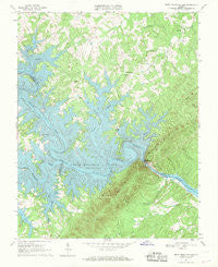
~ Smith Mountain Dam VA topo map, 1:24000 scale, 7.5 X 7.5 Minute, Historical, 1967, updated 1969 Online
Original price was: $14.95.$7.48Current price is: $7.48.50%
~ Stony Creek VA topo map, 1:24000 scale, 7.5 X 7.5 Minute, Historical, 1967, updated 1968 For Sale
Original price was: $14.95.$7.48Current price is: $7.48.50%
~ Whaleyville VA topo map, 1:24000 scale, 7.5 X 7.5 Minute, Historical, 1967, updated 1969 Discount
Original price was: $14.95.$7.48Current price is: $7.48.50%
~ Timberville VA topo map, 1:24000 scale, 7.5 X 7.5 Minute, Historical, 1967, updated 1986 Online Hot Sale
Original price was: $14.95.$7.48Current price is: $7.48.
~ Rock Spring Table NV topo map, 1:62500 scale, 15 X 15 Minute, Historical, 1965, updated 1968 Sale
Original price was: $14.95.$7.48Current price is: $7.48.