Search Product
Our Categories
Your Cart
Your order qualifies for free shipping!
Your shopping bag is currently empty
Continue Shopping
God Particle Wargaming Mat on Sale
Original price was: $54.95.$27.48Current price is: $27.48.
Pleasant Surprise Spacebar Keycap For Discount
Original price was: $9.95.$4.98Current price is: $4.98.


God Particle Extended Mousepad Online Hot Sale
Original price was: $36.95.$18.48Current price is: $18.48.
Home Sweet Home Day Tote Online now
Original price was: $22.95.$11.48Current price is: $11.48.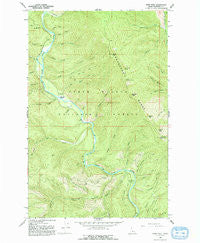
~ Pond Peak ID topo map, 1:24000 scale, 7.5 X 7.5 Minute, Historical, 1966, updated 1993 Discount
Original price was: $14.95.$7.48Current price is: $7.48.
Recently Viewed

~ Unionville IN topo map, 1:24000 scale, 7.5 X 7.5 Minute, Historical, 1966, updated 1990 Discount
Original price was: $14.95.$7.48Current price is: $7.48.


~ Ganado NE TX topo map, 1:24000 scale, 7.5 X 7.5 Minute, Historical, 1965, updated 1967 For Sale
Original price was: $14.95.$7.48Current price is: $7.48.
Chihuahua Spring Path Kitchen Towel on Sale
Original price was: $11.99.$6.00Current price is: $6.00.
Description
Pond Peak, Idaho, USGS topographic map dated 1966.
Includes geographic coordinates (latitude and longitude). This topographic map is suitable for hiking, camping, and exploring, or framing it as a wall map.
Printed on-demand using high resolution imagery, on heavy weight and acid free paper, or alternatively on a variety of synthetic materials.
Topos available on paper, Waterproof, Poly, or Tyvek. Usually shipping rolled, unless combined with other folded maps in one order.
- Product Number: USGS-5434617
- Free digital map download (high-resolution, GeoPDF): Pond Peak, Idaho (file size: 17 MB)
- Map Size: please refer to the dimensions of the GeoPDF map above
- Weight (paper map): ca. 55 grams
- Map Type: POD USGS Topographic Map
- Map Series: HTMC
- Map Verison: Historical
- Cell ID: 35943
- Scan ID: 237704
- Imprint Year: 1993
- Woodland Tint: Yes
- Aerial Photo Year: 1965
- Field Check Year: 1966
- Datum: NAD27
- Map Projection: Transverse Mercator
- Map published by United States Geological Survey
- Map Language: English
- Scanner Resolution: 600 dpi
- Map Cell Name: Pond Peak
- Grid size: 7.5 X 7.5 Minute
- Date on map: 1966
- Map Scale: 1:24000
- Geographical region: Idaho, United States
- Map Area ID: AREA47.87547.75-116.125-116
- Northwest corner Lat Long code: USGSNW47.875-116.125
- Northeast corner Lat Long code: USGSNE47.875-116
- Southwest corner Lat Long code: USGSSW47.75-116.125
- Southeast corner Lat Long code: USGSSE47.75-116
- Northern map edge Latitude: 47.875
- Southern map edge Latitude: 47.75
- Western map edge Longitude: -116.125
- Eastern map edge Longitude: -116
-
Neighboring Maps:
Northwest North Northeast West MAP East Southwest South Southeast All neighboring USGS topo maps are available for sale online at a variety of scales.
Spatial coverage:
Topo map Pond Peak, Idaho, covers the geographical area associated the following places:
– Big Hank Meadow – Guard Peak – Morris Creek – Downey Creek – Swift Creek – Rock City Cabin (historical) – Emery Creek – Ferguson Creek – Bennett Creek – Ash Creek – Little Sentinel Peak – Flat Creek – Cinnamon Creek – Shadow Falls – Taft Creek – Big Pool – Tourist Creek – Murray Division – Shoshone Range – North Grizzly Creek – Stony Creek – Big Hank Campground – Downey Peak – Big Hank Creek – Cardinal Creek – Ulm Creek – Sentinel Peak – Debbs Creek – Svee Creek – Gold Creek – Little Guard Peak – Nowhere Creek – Tent Creek – Lion Creek – Burnt Hill – Yellow Dog Creek – Valitons Creek – Pond Peak – Bruce Creek – Fern Falls – Bennett Peak – Little Guard Peak Lookout – President Creek – Rock City Pond Peak Trail – Teddy Creek – Little Canyon Creek – Long Pool – Beetle Creek – Wilson Creek – Devils Elbow Campground – Miners Creek – Little Lost Fork – Sentinel Creek – Brett Creek
Additional information
Print Material Regular Paper, Waterproof, Polypropylene, Tyvek
Related products
50%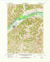
~ Boscobel WI topo map, 1:62500 scale, 15 X 15 Minute, Historical, 1967, updated 1970 Online now
Original price was: $14.95.$7.48Current price is: $7.48.50%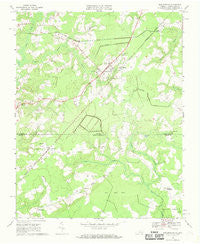
~ Whaleyville VA topo map, 1:24000 scale, 7.5 X 7.5 Minute, Historical, 1967, updated 1969 Discount
Original price was: $14.95.$7.48Current price is: $7.48.50%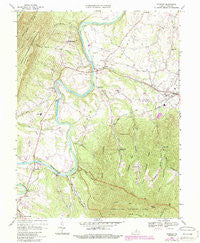
~ Stanley VA topo map, 1:24000 scale, 7.5 X 7.5 Minute, Historical, 1967, updated 1987 Fashion
Original price was: $14.95.$7.48Current price is: $7.48.50%
~ Whaleyville VA topo map, 1:24000 scale, 7.5 X 7.5 Minute, Historical, 1967, updated 1981 Hot on Sale
Original price was: $14.95.$7.48Current price is: $7.48.50%
~ Sussex VA topo map, 1:24000 scale, 7.5 X 7.5 Minute, Historical, 1967, updated 1990 Discount
Original price was: $14.95.$7.48Current price is: $7.48.50%
~ Stony Creek VA topo map, 1:24000 scale, 7.5 X 7.5 Minute, Historical, 1967, updated 1983 on Sale
Original price was: $14.95.$7.48Current price is: $7.48.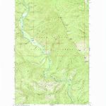
~ Pond Peak ID topo map, 1:24000 scale, 7.5 X 7.5 Minute, Historical, 1966, updated 1993 Discount
Original price was: $14.95.$7.48Current price is: $7.48.