Search Product
Our Categories
Your Cart
Your order qualifies for free shipping!
Your shopping bag is currently empty
Continue Shopping
God Particle Wargaming Mat on Sale
Original price was: $54.95.$27.48Current price is: $27.48.
Pleasant Surprise Spacebar Keycap For Discount
Original price was: $9.95.$4.98Current price is: $4.98.


God Particle Extended Mousepad Online Hot Sale
Original price was: $36.95.$18.48Current price is: $18.48.
Home Sweet Home Day Tote Online now
Original price was: $22.95.$11.48Current price is: $11.48.
~ Lansdale PA topo map, 1:24000 scale, 7.5 X 7.5 Minute, Historical, 1966, updated 1983 Online Hot Sale
Original price was: $14.95.$7.48Current price is: $7.48.
Recently Viewed
~ Clinton NW IA topo map, 1:24000 scale, 7.5 X 7.5 Minute, Historical, 1967, updated 1969 Online Sale
Original price was: $14.95.$7.48Current price is: $7.48.Description
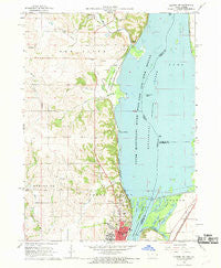
Lansdale, Pennsylvania, USGS topographic map dated 1966.
Includes geographic coordinates (latitude and longitude). This topographic map is suitable for hiking, camping, and exploring, or framing it as a wall map.
Printed on-demand using high resolution imagery, on heavy weight and acid free paper, or alternatively on a variety of synthetic materials.
Topos available on paper, Waterproof, Poly, or Tyvek. Usually shipping rolled, unless combined with other folded maps in one order.
- Product Number: USGS-5325150
- Free digital map download (high-resolution, GeoPDF): Lansdale, Pennsylvania (file size: 13 MB)
- Map Size: please refer to the dimensions of the GeoPDF map above
- Weight (paper map): ca. 55 grams
- Map Type: POD USGS Topographic Map
- Map Series: HTMC
- Map Verison: Historical
- Cell ID: 24936
- Scan ID: 171058
- Imprint Year: 1983
- Woodland Tint: Yes
- Photo Revision Year: 1983
- Aerial Photo Year: 1981
- Edit Year: 1983
- Field Check Year: 1966
- Datum: NAD27
- Map Projection: Polyconic
- Map published by United States Geological Survey
- Map Language: English
- Scanner Resolution: 600 dpi
- Map Cell Name: Lansdale
- Grid size: 7.5 X 7.5 Minute
- Date on map: 1966
- Map Scale: 1:24000
- Geographical region: Pennsylvania, United States
- Map Area ID: AREA40.2540.125-75.375-75.25
- Northwest corner Lat Long code: USGSNW40.25-75.375
- Northeast corner Lat Long code: USGSNE40.25-75.25
- Southwest corner Lat Long code: USGSSW40.125-75.375
- Southeast corner Lat Long code: USGSSE40.125-75.25
- Northern map edge Latitude: 40.25
- Southern map edge Latitude: 40.125
- Western map edge Longitude: -75.375
- Eastern map edge Longitude: -75.25
-
Neighboring Maps:
Northwest North Northeast West MAP East Southwest South Southeast All neighboring USGS topo maps are available for sale online at a variety of scales.
Spatial coverage:
Topo map Lansdale, Pennsylvania, covers the geographical area associated the following places:
– Shady Grove Manor – Wales Junction – Whitpain Manor – Blue Bell Square – Sunny Ayr Estates – Heebnerville – Gwynedd Club – Normandy Farms Estates – Harley Corners – Village Circle – Ager Tract – Mews at Blue Bell – Oxford Manor – Jeffersonville – Gwynedd Chase – Foulkeways – Kulpsville – Dekalb Park – Center Square – Birkdale – Gwynedd Acres – Blue Bell – Grand View Heights – Hillcrest Meadows – Shinnecock – Inverrary – Gleneagles – Barley Lane – Rolling Meadow Estates – Cardinal Hollow – Sugarvalley – Lansdale – Townline – Norritonville – Willowyck – Mermaid Estates – Village of Willowbend – Sheffield Village – Whitpain Woods – Inglewood – Whitpain Hills – Inglewood Gardens – Gwynedd – Hunter Villa – Welch Village – Winding Brook Estates – Penn Brooke – Center Square Green – Executive House (subdivision) – Brittany Pointe Estates – Gwynedd Heights – Wynwood Estates – Norrition Woods – East Norriton – DeKalb Farms – Oak Park – Narcissa – Norriton East – West Point – Far-A-Field – Towamencin Village – Gwynedd Square – Yorkshires of Blue Bell – Imperial Arms – Cedars – Meadow Wick – Norris Hills Court – Glengary Highlands – Plymouth Valley – Meadowlands Manor – Bethel Hill – Hooverton – Merrybrook – Belfry – Madison Ridge – Coleston – Sunny Brook Estates – Blue Bell Road Manor – Acorn – Penn Square – Stuarts Keep – Five Points – Cambridge Knoll – Bayhill – Bethel Grant – Calmensin – Blue Bell Crossing – Muirfield – Belfry Meadow – Clover Crest – Blue Bell Glenn – Valentine Estates – North Wales – Gwynedd Woods – Chatham Village of Towamencin – Wissahickon Park Gardens – Springtown – Franklinville – Washington Square – Kimberly Knoll
Additional information
Print Material Regular Paper, Waterproof, Polypropylene, Tyvek
Related products
50%
~ Whaleyville VA topo map, 1:24000 scale, 7.5 X 7.5 Minute, Historical, 1967, updated 1981 Hot on Sale
Original price was: $14.95.$7.48Current price is: $7.48.50%
~ West Augusta VA topo map, 1:24000 scale, 7.5 X 7.5 Minute, Historical, 1967, updated 1991 Online now
Original price was: $14.95.$7.48Current price is: $7.48.50%
~ Sussex VA topo map, 1:24000 scale, 7.5 X 7.5 Minute, Historical, 1967, updated 1968 Online Hot Sale
Original price was: $14.95.$7.48Current price is: $7.48.50%
~ Stuart VA topo map, 1:24000 scale, 7.5 X 7.5 Minute, Historical, 1967, updated 1971 For Sale
Original price was: $14.95.$7.48Current price is: $7.48.50%
~ Stokesville VA topo map, 1:24000 scale, 7.5 X 7.5 Minute, Historical, 1967, updated 1968 Supply
Original price was: $14.95.$7.48Current price is: $7.48.50%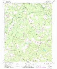
~ Sussex VA topo map, 1:24000 scale, 7.5 X 7.5 Minute, Historical, 1967, updated 1990 Discount
Original price was: $14.95.$7.48Current price is: $7.48.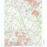
~ Lansdale PA topo map, 1:24000 scale, 7.5 X 7.5 Minute, Historical, 1966, updated 1983 Online Hot Sale
Original price was: $14.95.$7.48Current price is: $7.48.