Search Product
Our Categories
Your Cart
Your order qualifies for free shipping!
Your shopping bag is currently empty
Continue Shopping
God Particle Wargaming Mat on Sale
Original price was: $54.95.$27.48Current price is: $27.48.
Pleasant Surprise Spacebar Keycap For Discount
Original price was: $9.95.$4.98Current price is: $4.98.


God Particle Extended Mousepad Online Hot Sale
Original price was: $36.95.$18.48Current price is: $18.48.
Home Sweet Home Day Tote Online now
Original price was: $22.95.$11.48Current price is: $11.48.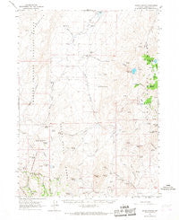
~ Idaho Canyon NV topo map, 1:62500 scale, 15 X 15 Minute, Historical, 1965, updated 1967 Sale
Original price was: $14.95.$7.48Current price is: $7.48.
Recently Viewed

Summer Breezes Palm Tree Dish Drying Mat Fashion
Original price was: $16.99.$8.50Current price is: $8.50.
Great Dane Spring Path Kitchen Towel Sale
Original price was: $11.99.$6.00Current price is: $6.00.


Cocker Spaniel My Angel Greeting Cards Pack of 8 Online
Original price was: $14.99.$7.50Current price is: $7.50.
Glimmer Forest Dice Bag Sale
Original price was: $12.95.$6.48Current price is: $6.48.Description
Idaho Canyon, Nevada, USGS topographic map dated 1965.
Includes geographic coordinates (latitude and longitude). This topographic map is suitable for hiking, camping, and exploring, or framing it as a wall map.
Printed on-demand using high resolution imagery, on heavy weight and acid free paper, or alternatively on a variety of synthetic materials.
Topos available on paper, Waterproof, Poly, or Tyvek. Usually shipping rolled, unless combined with other folded maps in one order.
- Product Number: USGS-5572670
- Free digital map download (high-resolution, GeoPDF): Idaho Canyon, Nevada (file size: 7 MB)
- Map Size: please refer to the dimensions of the GeoPDF map above
- Weight (paper map): ca. 55 grams
- Map Type: POD USGS Topographic Map
- Map Series: HTMC
- Map Verison: Historical
- Cell ID: 55651
- Scan ID: 321002
- Imprint Year: 1967
- Woodland Tint: Yes
- Aerial Photo Year: 1963
- Field Check Year: 1965
- Datum: NAD27
- Map Projection: Polyconic
- Map published by United States Geological Survey
- Map Language: English
- Scanner Resolution: 600 dpi
- Map Cell Name: Idaho Canyon
- Grid size: 15 X 15 Minute
- Date on map: 1965
- Map Scale: 1:62500
- Geographical region: Nevada, United States
- Map Area ID: AREA41.7541.5-119-118.75
- Northwest corner Lat Long code: USGSNW41.75-119
- Northeast corner Lat Long code: USGSNE41.75-118.75
- Southwest corner Lat Long code: USGSSW41.5-119
- Southeast corner Lat Long code: USGSSE41.5-118.75
- Northern map edge Latitude: 41.75
- Southern map edge Latitude: 41.5
- Western map edge Longitude: -119
- Eastern map edge Longitude: -118.75
-
Neighboring Maps:
Northwest North Northeast West MAP East Southwest South Southeast All neighboring USGS topo maps are available for sale online at a variety of scales.
Spatial coverage:
Topo map Idaho Canyon, Nevada, covers the geographical area associated the following places:
– Woodcamp Springs – Summer Camp Canyon – Cow Creek – Rodeo Flat – New York Peak – Knott Creek Reservoir Dam – Cove Meadow Mining District – Summit Lake Division – Corral Creek – Idaho Canyon Spring – Buck Pasture – Wood Canyon – Rock Spring – Idaho Canyon Range – Bartlett Mine – Indian Spring – Gridley Springs – Juanita Mine – West Spring – Corral Spring – McCully Spring – Bartlett Peak – Cove Meadows – Wheeler Springs – Cove Meadow Mine – Pearl Camp – Center Creek – Lahontan Cutthroat Trout Natural Area – Dry Lake – Knott Creek Channel – Summer Camp – Dry Lake Springs – Trail Canyon – Little Onion Reservoir – Craine Spring – McCully Cabin – Columbia Mine – Alkali Flat – South Fork Mahogany Creek – Josie Pearl Spring – Middle Spring – Little Idaho Canyon – Lone Meadow Spring – Summit Lake Mountain – Pole Creek – Hollywood Meadow – Knott Creek Reservoir – Parman Spring – Horseshoe Bend – Cove Camp – Big Mountain – Knott Creek Ranch – Cove Creek – Willow Spring – Santa Claus Spring – Knott Creek – Tin Trough Spring – Little Onion Dam – Trough Spring – Stanley Camp – Idaho Canyon – Summit Spring – West Creek
Additional information
Print Material Regular Paper, Waterproof, Polypropylene, Tyvek
Related products
50%
~ Stony Creek VA topo map, 1:24000 scale, 7.5 X 7.5 Minute, Historical, 1967, updated 1968 For Sale
Original price was: $14.95.$7.48Current price is: $7.48.50%
~ Timberville VA topo map, 1:24000 scale, 7.5 X 7.5 Minute, Historical, 1967, updated 1969 For Sale
Original price was: $14.95.$7.48Current price is: $7.48.50%
~ Timberville VA topo map, 1:24000 scale, 7.5 X 7.5 Minute, Historical, 1967, updated 1986 Online Hot Sale
Original price was: $14.95.$7.48Current price is: $7.48.50%
~ Sussex VA topo map, 1:24000 scale, 7.5 X 7.5 Minute, Historical, 1967, updated 1990 Discount
Original price was: $14.95.$7.48Current price is: $7.48.50%
~ Stony Creek VA topo map, 1:24000 scale, 7.5 X 7.5 Minute, Historical, 1967, updated 1986 Online now
Original price was: $14.95.$7.48Current price is: $7.48.50%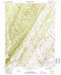
~ Timberville VA topo map, 1:24000 scale, 7.5 X 7.5 Minute, Historical, 1967, updated 1987 Online
Original price was: $14.95.$7.48Current price is: $7.48.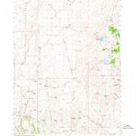
~ Idaho Canyon NV topo map, 1:62500 scale, 15 X 15 Minute, Historical, 1965, updated 1967 Sale
Original price was: $14.95.$7.48Current price is: $7.48.