Search Product
Our Categories
Your Cart
Your order qualifies for free shipping!
Your shopping bag is currently empty
Continue Shopping
God Particle Wargaming Mat on Sale
Original price was: $54.95.$27.48Current price is: $27.48.
Pleasant Surprise Spacebar Keycap For Discount
Original price was: $9.95.$4.98Current price is: $4.98.


God Particle Extended Mousepad Online Hot Sale
Original price was: $36.95.$18.48Current price is: $18.48.
Home Sweet Home Day Tote Online now
Original price was: $22.95.$11.48Current price is: $11.48.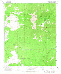
~ Humphreys Peak AZ topo map, 1:24000 scale, 7.5 X 7.5 Minute, Historical, 1966, updated 1968 Fashion
Original price was: $14.95.$7.48Current price is: $7.48.
Recently Viewed
~ Shissler Peak ID topo map, 1:24000 scale, 7.5 X 7.5 Minute, Historical, 1966, updated 1968 Fashion
Original price was: $14.95.$7.48Current price is: $7.48.

Irish Setter Christmas Reindeer Greeting Cards Pack of 8 Cheap
Original price was: $14.99.$7.50Current price is: $7.50.
Description
Humphreys Peak, Arizona, USGS topographic map dated 1966.
Includes geographic coordinates (latitude and longitude). This topographic map is suitable for hiking, camping, and exploring, or framing it as a wall map.
Printed on-demand using high resolution imagery, on heavy weight and acid free paper, or alternatively on a variety of synthetic materials.
Topos available on paper, Waterproof, Poly, or Tyvek. Usually shipping rolled, unless combined with other folded maps in one order.
- Product Number: USGS-5552916
- Free digital map download (high-resolution, GeoPDF): Humphreys Peak, Arizona (file size: 11 MB)
- Map Size: please refer to the dimensions of the GeoPDF map above
- Weight (paper map): ca. 55 grams
- Map Type: POD USGS Topographic Map
- Map Series: HTMC
- Map Verison: Historical
- Cell ID: 21469
- Scan ID: 311853
- Imprint Year: 1968
- Woodland Tint: Yes
- Aerial Photo Year: 1964
- Field Check Year: 1966
- Datum: NAD27
- Map Projection: Polyconic
- Map published by United States Geological Survey
- Map Language: English
- Scanner Resolution: 600 dpi
- Map Cell Name: Humphreys Peak
- Grid size: 7.5 X 7.5 Minute
- Date on map: 1966
- Map Scale: 1:24000
- Geographical region: Arizona, United States
- Map Area ID: AREA35.37535.25-111.75-111.625
- Northwest corner Lat Long code: USGSNW35.375-111.75
- Northeast corner Lat Long code: USGSNE35.375-111.625
- Southwest corner Lat Long code: USGSSW35.25-111.75
- Southeast corner Lat Long code: USGSSE35.25-111.625
- Northern map edge Latitude: 35.375
- Southern map edge Latitude: 35.25
- Western map edge Longitude: -111.75
- Eastern map edge Longitude: -111.625
-
Neighboring Maps:
Northwest North Northeast West MAP East Southwest South Southeast All neighboring USGS topo maps are available for sale online at a variety of scales.
Spatial coverage:
Topo map Humphreys Peak, Arizona, covers the geographical area associated the following places:
– Jack Smith Spring – Schultz Peak – Rees Peak – Lew Tank – Snowslide Spring – Fern Mountain – Fern Mountain Tank – Raspberry Spring – Taylor Spring – Doyle Saddle – Dry Lake Hills – G. A. Pearson Natural Area – Big Leroux Spring – Leroux Spring – Doyle Peak – High Tank – Summit Fire District Station 36 – Snowbowl Ski Area – Freidlein Prairie – Michelbach Ranch – Orion Spring – Viet Spring – Alfa Fia Tank – Schultz Tank – High Tank – Fort Valley Experimental Forest – Bismarck Lake – San Francisco Peaks Natural Area – Fremont Saddle – Inner Basin – Little Spring – Beard Spring – Fort Valley Experimental Forest Station – Bear Paw Spring – Windmill Tank – Agassiz Peak – Aspen Tank – Kachina Peaks Wilderness – Little Leroux Spring – Chimney Spring – Galinas Tank – Arizona Snow Bowl – Aubineau Peak – San Francisco Mountain – Fort Valley Census Designated Place – Windmill Tank – Beard Canyon – Humphreys Peak – Hot Shot Headquarters – Philomena Spring – Arizona Snow Bowl Campground – Schultz Pass – Hart Prairie – Fremont Peak – Hart Prairie Tank – Doyle Spring – Meadow Tank – Bismarck Tank – Domingo Tank – Flagstaff Spring – Freidlein Prairie Tank – Aspen Spring
Additional information
Print Material Regular Paper, Waterproof, Polypropylene, Tyvek
Related products
50%
~ Singers Glen VA topo map, 1:24000 scale, 7.5 X 7.5 Minute, Historical, 1967, updated 1987 Online now
Original price was: $14.95.$7.48Current price is: $7.48.50%
~ Smith Mountain Dam VA topo map, 1:24000 scale, 7.5 X 7.5 Minute, Historical, 1967, updated 1969 Online
Original price was: $14.95.$7.48Current price is: $7.48.50%
~ Simeon VA topo map, 1:24000 scale, 7.5 X 7.5 Minute, Historical, 1967, updated 1969 Online Hot Sale
Original price was: $14.95.$7.48Current price is: $7.48.50%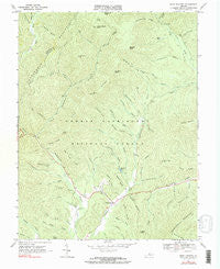
~ West Augusta VA topo map, 1:24000 scale, 7.5 X 7.5 Minute, Historical, 1967, updated 1991 For Cheap
Original price was: $14.95.$7.48Current price is: $7.48.50%
~ Timberville VA topo map, 1:24000 scale, 7.5 X 7.5 Minute, Historical, 1967, updated 1987 Online
Original price was: $14.95.$7.48Current price is: $7.48.50%
~ Stanley VA topo map, 1:24000 scale, 7.5 X 7.5 Minute, Historical, 1967, updated 1987 Fashion
Original price was: $14.95.$7.48Current price is: $7.48.
~ Humphreys Peak AZ topo map, 1:24000 scale, 7.5 X 7.5 Minute, Historical, 1966, updated 1968 Fashion
Original price was: $14.95.$7.48Current price is: $7.48.