Search Product
Our Categories
Your Cart
Your order qualifies for free shipping!
Your shopping bag is currently empty
Continue Shopping
God Particle Wargaming Mat on Sale
Original price was: $54.95.$27.48Current price is: $27.48.
Pleasant Surprise Spacebar Keycap For Discount
Original price was: $9.95.$4.98Current price is: $4.98.


God Particle Extended Mousepad Online Hot Sale
Original price was: $36.95.$18.48Current price is: $18.48.
Home Sweet Home Day Tote Online now
Original price was: $22.95.$11.48Current price is: $11.48.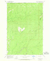
~ Hemlock Butte ID topo map, 1:24000 scale, 7.5 X 7.5 Minute, Historical, 1966, updated 1968 Online now
Original price was: $14.95.$7.48Current price is: $7.48.
Recently Viewed
~ Midland MI topo map, 1:250000 scale, 1 X 2 Degree, Historical, 1966, updated 1966 Online now
Original price was: $24.95.$12.48Current price is: $12.48.
~ Toboggan Ridge ID topo map, 1:24000 scale, 7.5 X 7.5 Minute, Historical, 1966, updated 1984 Hot on Sale
Original price was: $14.95.$7.48Current price is: $7.48.~ Hemlock Butte ID topo map, 1:24000 scale, 7.5 X 7.5 Minute, Historical, 1966, updated 1968 Online now
Original price was: $14.95.$7.48Current price is: $7.48.Description
Hemlock Butte, Idaho, USGS topographic map dated 1966.
Includes geographic coordinates (latitude and longitude). This topographic map is suitable for hiking, camping, and exploring, or framing it as a wall map.
Printed on-demand using high resolution imagery, on heavy weight and acid free paper, or alternatively on a variety of synthetic materials.
Topos available on paper, Waterproof, Poly, or Tyvek. Usually shipping rolled, unless combined with other folded maps in one order.
- Product Number: USGS-5432522
- Free digital map download (high-resolution, GeoPDF): Hemlock Butte, Idaho (file size: 11 MB)
- Map Size: please refer to the dimensions of the GeoPDF map above
- Weight (paper map): ca. 55 grams
- Map Type: POD USGS Topographic Map
- Map Series: HTMC
- Map Verison: Historical
- Cell ID: 20062
- Scan ID: 236469
- Imprint Year: 1968
- Woodland Tint: Yes
- Aerial Photo Year: 1963
- Field Check Year: 1966
- Datum: NAD27
- Map Projection: Polyconic
- Map published by United States Geological Survey
- Map Language: English
- Scanner Resolution: 600 dpi
- Map Cell Name: Hemlock Butte
- Grid size: 7.5 X 7.5 Minute
- Date on map: 1966
- Map Scale: 1:24000
- Geographical region: Idaho, United States
- Map Area ID: AREA46.546.375-115.75-115.625
- Northwest corner Lat Long code: USGSNW46.5-115.75
- Northeast corner Lat Long code: USGSNE46.5-115.625
- Southwest corner Lat Long code: USGSSW46.375-115.75
- Southeast corner Lat Long code: USGSSE46.375-115.625
- Northern map edge Latitude: 46.5
- Southern map edge Latitude: 46.375
- Western map edge Longitude: -115.75
- Eastern map edge Longitude: -115.625
-
Neighboring Maps:
Northwest North Northeast West MAP East Southwest South Southeast All neighboring USGS topo maps are available for sale online at a variety of scales.
Spatial coverage:
Topo map Hemlock Butte, Idaho, covers the geographical area associated the following places:
– Gezel Creek – French Saddle – Relaskop Creek – Big Gulch – Mox Creek – Thompson Gulch – Yoosa Creek – Siberia Creek – Trapper Gulch – Pistol Grip Mine – Sawmill Creek – Rescue Creek – Nelson Creek – Armstrong Gulch – Hemlock Butte – Chamook Creek – Alder Creek – Dewey Creek – Camp Creek – Cole Creek – Red Cloud Mine – Jenson Creek – Dan Lee Ridge – Belle Creek – Dutchman Creek – Pioneer Mine – Johnson Draw – Winter Draw – Greer Gulch – Lost Hat Saddle – Rosebud Creek – Belle Creek Campground
Additional information
Print Material Regular Paper, Waterproof, Polypropylene, Tyvek
Related products
50%
~ Timberville VA topo map, 1:24000 scale, 7.5 X 7.5 Minute, Historical, 1967, updated 1969 For Sale
Original price was: $14.95.$7.48Current price is: $7.48.50%
~ Stuart VA topo map, 1:24000 scale, 7.5 X 7.5 Minute, Historical, 1967, updated 1971 For Sale
Original price was: $14.95.$7.48Current price is: $7.48.50%
~ Stony Creek VA topo map, 1:24000 scale, 7.5 X 7.5 Minute, Historical, 1967, updated 1983 on Sale
Original price was: $14.95.$7.48Current price is: $7.48.50%
~ Whaleyville VA topo map, 1:24000 scale, 7.5 X 7.5 Minute, Historical, 1967, updated 1969 Discount
Original price was: $14.95.$7.48Current price is: $7.48.50%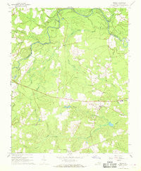
~ Sussex VA topo map, 1:24000 scale, 7.5 X 7.5 Minute, Historical, 1967, updated 1968 Online Hot Sale
Original price was: $14.95.$7.48Current price is: $7.48.50%
~ Stony Creek VA topo map, 1:24000 scale, 7.5 X 7.5 Minute, Historical, 1967, updated 1986 Online now
Original price was: $14.95.$7.48Current price is: $7.48.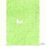
~ Hemlock Butte ID topo map, 1:24000 scale, 7.5 X 7.5 Minute, Historical, 1966, updated 1968 Online now
Original price was: $14.95.$7.48Current price is: $7.48.