Search Product
Our Categories
Your Cart
Your order qualifies for free shipping!
Your shopping bag is currently empty
Continue Shopping
God Particle Wargaming Mat on Sale
Original price was: $54.95.$27.48Current price is: $27.48.
Pleasant Surprise Spacebar Keycap For Discount
Original price was: $9.95.$4.98Current price is: $4.98.


God Particle Extended Mousepad Online Hot Sale
Original price was: $36.95.$18.48Current price is: $18.48.
Home Sweet Home Day Tote Online now
Original price was: $22.95.$11.48Current price is: $11.48.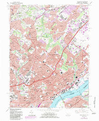
~ Frankford PA topo map, 1:24000 scale, 7.5 X 7.5 Minute, Historical, 1967, updated 1983 Hot on Sale
Original price was: $14.95.$7.48Current price is: $7.48.
Recently Viewed

British Longhair Cat in Fall Leaves Pair of Pot Holders Online
Original price was: $19.99.$10.00Current price is: $10.00.


Pug in Sunflowers Can or Bottle Hugger Discount
Original price was: $4.99.$2.50Current price is: $2.50.
~ Bedal WA topo map, 1:24000 scale, 7.5 X 7.5 Minute, Historical, 1966, updated 1973 Sale
Original price was: $14.95.$7.48Current price is: $7.48.Description
Frankford, Pennsylvania, USGS topographic map dated 1967.
Includes geographic coordinates (latitude and longitude). This topographic map is suitable for hiking, camping, and exploring, or framing it as a wall map.
Printed on-demand using high resolution imagery, on heavy weight and acid free paper, or alternatively on a variety of synthetic materials.
Topos available on paper, Waterproof, Poly, or Tyvek. Usually shipping rolled, unless combined with other folded maps in one order.
- Product Number: USGS-5323898
- Free digital map download (high-resolution, GeoPDF): Frankford, Pennsylvania (file size: 17 MB)
- Map Size: please refer to the dimensions of the GeoPDF map above
- Weight (paper map): ca. 55 grams
- Map Type: POD USGS Topographic Map
- Map Series: HTMC
- Map Verison: Historical
- Cell ID: 70117
- Scan ID: 172544
- Imprint Year: 1983
- Woodland Tint: Yes
- Photo Revision Year: 1983
- Aerial Photo Year: 1981
- Edit Year: 1983
- Field Check Year: 1967
- Survey Year: 1947
- Datum: NAD27
- Map Projection: Polyconic
- Map published by United States Geological Survey
- Map Language: English
- Scanner Resolution: 600 dpi
- Map Cell Name: Frankford
- Grid size: 7.5 X 7.5 Minute
- Date on map: 1967
- Map Scale: 1:24000
- Geographical region: Pennsylvania, United States
- Map Area ID: AREA40.12540-75.125-75
- Northwest corner Lat Long code: USGSNW40.125-75.125
- Northeast corner Lat Long code: USGSNE40.125-75
- Southwest corner Lat Long code: USGSSW40-75.125
- Southeast corner Lat Long code: USGSSE40-75
- Northern map edge Latitude: 40.125
- Southern map edge Latitude: 40
- Western map edge Longitude: -75.125
- Eastern map edge Longitude: -75
-
Neighboring Maps:
Northwest North Northeast West MAP East Southwest South Southeast All neighboring USGS topo maps are available for sale online at a variety of scales.
Spatial coverage:
Topo map Frankford, Pennsylvania, covers the geographical area associated the following places:
– Elkins Park Gardens – Volunteertown – Crosswicks – Abington – Philmont – Frankford – Holme Circle – Rydal Estates – Oak Lane Manor – Juniata – Oaklane – Blue Grass – Wissinoming – Wyndmoor Estates – Upper Holmesburg – Rydal Green – Coventry House – Summerdale – Cedar Grove – McKinley – Valley Falls – Bustleton – Rydal – Ashmead Village – Lawn Crest – Vereeville – Lexington Park – Winchester Park – Crescentville – Meadowbrook – Bridesburg – Chapel Hill Manor – Cheltenham Village – Gloria Dei Towers – Rhawnhurst – Torresdale – Hollywood – Lawndale – Tacony – Walnut Hill – Oxford Village – Mayfair – Burholme – Oxford Circle – Foxcroft Square – Cheltenham – Holmesburg – Somerton – Huntingdon Valley – Lagrange – Rockledge – Oak Lane – Harrisburg – Lawncrest – Noble – Riverton – Palmyra – Pauls Run – Rydall Park – Fitler – Rydal East – Ashton Wooden Bridge – High Rue – Pennypack Woods – Pennypack – Ryers – Rydal Park – Bethayres – Fox Chase – Northwood – Olney
Additional information
Print Material Regular Paper, Waterproof, Polypropylene, Tyvek
Related products
50%
~ Timberville VA topo map, 1:24000 scale, 7.5 X 7.5 Minute, Historical, 1967, updated 1987 Online
Original price was: $14.95.$7.48Current price is: $7.48.50%
~ Smith Mountain Dam VA topo map, 1:24000 scale, 7.5 X 7.5 Minute, Historical, 1967, updated 1984 Online Hot Sale
Original price was: $14.95.$7.48Current price is: $7.48.50%
~ Whaleyville VA topo map, 1:24000 scale, 7.5 X 7.5 Minute, Historical, 1967, updated 1981 Hot on Sale
Original price was: $14.95.$7.48Current price is: $7.48.50%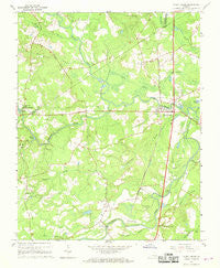
~ Stony Creek VA topo map, 1:24000 scale, 7.5 X 7.5 Minute, Historical, 1967, updated 1968 For Sale
Original price was: $14.95.$7.48Current price is: $7.48.50%
~ Stuart VA topo map, 1:24000 scale, 7.5 X 7.5 Minute, Historical, 1967, updated 1971 For Sale
Original price was: $14.95.$7.48Current price is: $7.48.50%
~ Simeon VA topo map, 1:24000 scale, 7.5 X 7.5 Minute, Historical, 1967, updated 1969 Online Hot Sale
Original price was: $14.95.$7.48Current price is: $7.48.
~ Frankford PA topo map, 1:24000 scale, 7.5 X 7.5 Minute, Historical, 1967, updated 1983 Hot on Sale
Original price was: $14.95.$7.48Current price is: $7.48.