Search Product
Our Categories
Your Cart
Your order qualifies for free shipping!
Your shopping bag is currently empty
Continue Shopping
God Particle Wargaming Mat on Sale
Original price was: $54.95.$27.48Current price is: $27.48.
Pleasant Surprise Spacebar Keycap For Discount
Original price was: $9.95.$4.98Current price is: $4.98.


God Particle Extended Mousepad Online Hot Sale
Original price was: $36.95.$18.48Current price is: $18.48.
Home Sweet Home Day Tote Online now
Original price was: $22.95.$11.48Current price is: $11.48.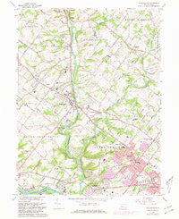
~ Collegeville PA topo map, 1:24000 scale, 7.5 X 7.5 Minute, Historical, 1966, updated 1981 For Sale
Original price was: $14.95.$7.48Current price is: $7.48.


Description
Collegeville, Pennsylvania, USGS topographic map dated 1966.
Includes geographic coordinates (latitude and longitude). This topographic map is suitable for hiking, camping, and exploring, or framing it as a wall map.
Printed on-demand using high resolution imagery, on heavy weight and acid free paper, or alternatively on a variety of synthetic materials.
Topos available on paper, Waterproof, Poly, or Tyvek. Usually shipping rolled, unless combined with other folded maps in one order.
- Product Number: USGS-5322948
- Free digital map download (high-resolution, GeoPDF): Collegeville, Pennsylvania (file size: 11 MB)
- Map Size: please refer to the dimensions of the GeoPDF map above
- Weight (paper map): ca. 55 grams
- Map Type: POD USGS Topographic Map
- Map Series: HTMC
- Map Verison: Historical
- Cell ID: 69707
- Scan ID: 172353
- Imprint Year: 1981
- Woodland Tint: Yes
- Photo Revision Year: 1973
- Aerial Photo Year: 1973
- Field Check Year: 1966
- Datum: NAD27
- Map Projection: Polyconic
- Map published by United States Geological Survey
- Map Language: English
- Scanner Resolution: 600 dpi
- Map Cell Name: Collegeville
- Grid size: 7.5 X 7.5 Minute
- Date on map: 1966
- Map Scale: 1:24000
- Geographical region: Pennsylvania, United States
- Map Area ID: AREA40.2540.125-75.5-75.375
- Northwest corner Lat Long code: USGSNW40.25-75.5
- Northeast corner Lat Long code: USGSNE40.25-75.375
- Southwest corner Lat Long code: USGSSW40.125-75.5
- Southeast corner Lat Long code: USGSSE40.125-75.375
- Northern map edge Latitude: 40.25
- Southern map edge Latitude: 40.125
- Western map edge Longitude: -75.5
- Eastern map edge Longitude: -75.375
-
Neighboring Maps:
Northwest North Northeast West MAP East Southwest South Southeast All neighboring USGS topo maps are available for sale online at a variety of scales.
Spatial coverage:
Topo map Collegeville, Pennsylvania, covers the geographical area associated the following places:
– Palm Beach Farm – Iron Bridge Estates – Ironbridge Estates – Harmony Towne – Sugar Hill Farms – Warlgya Tract – Perkiomen Greene – Mill Grove – Port Providence – The Estates of Audubon South – Regency Knoll – Gypsy Rose Estates – Greenshire Estates – Pennypacker Road – Fairview Village – Collegeville Greene – Coldspring Crossing – West Norriton – The Colony at Valley Forge – The Woods at Providence Reserve – Weatherlea – The Reserve – Creekwood Village – The Meadows at Providence Reserve – Estates at Faraway Farm – Arbors at Providence – Estates at Collegeville – Wooded Glen – Trooper Mobile Home Park – Upper Fairview – Norrington Knoll – The Estates of Audubon North – Evansburg – Green Tree – Colony Arms – Trooper – Trappe – Lucon – Audubon Gardens – Chadwick Place – Graterford – Sunnyside Farms – Fox Heath – Pineview Estates – Evansburg Crossing – Audubon Shrine – Creamery – Moister Tract – Mews at Valley Forge – Skippack – Pin Oak Estates – Donny Brook Estates – Skippack Ridge – Eagleville – The Estates at Fawn Ridge – Collegeville Glen – Collegeville Crossing – Villa of Flair Skippack Village – Crestview at Skippack – Providence Green – Collegeville – Fair Hills – Olde Village – Providence View – Valley Hi East – Rahns – Cassel Mill Farms – Lochwood Estates – Providence Knoll – Perkiomen – Yerkes – Trappe Meadows – Eagel Stream – Greenview Estates – Arcola – The Pines – Pennington Reserve at Upper Providence – Providence Meadows – Providence Crossing – Collegeville Arms – Heather View – Providence Ridge – Providence Oaks – Oaks – Berwick Place – Arrowhead Knoll – Frog Hollow Estates – Abruzzi Estates – Perkiomen Woods – Audobon Gardens – Audubon
Additional information
Print Material Regular Paper, Waterproof, Polypropylene, Tyvek
Related products
50%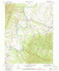
~ Stanley VA topo map, 1:24000 scale, 7.5 X 7.5 Minute, Historical, 1967, updated 1987 Fashion
Original price was: $14.95.$7.48Current price is: $7.48.50%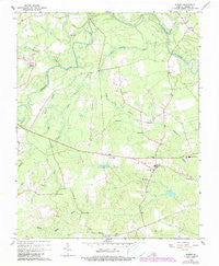
~ Sussex VA topo map, 1:24000 scale, 7.5 X 7.5 Minute, Historical, 1967, updated 1990 Discount
Original price was: $14.95.$7.48Current price is: $7.48.50%
~ Simeon VA topo map, 1:24000 scale, 7.5 X 7.5 Minute, Historical, 1967, updated 1969 Online Hot Sale
Original price was: $14.95.$7.48Current price is: $7.48.50%
~ Stuart VA topo map, 1:24000 scale, 7.5 X 7.5 Minute, Historical, 1967, updated 1971 For Sale
Original price was: $14.95.$7.48Current price is: $7.48.50%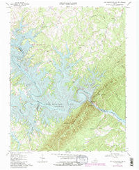
~ Smith Mountain Dam VA topo map, 1:24000 scale, 7.5 X 7.5 Minute, Historical, 1967, updated 1984 Online Sale
Original price was: $14.95.$7.48Current price is: $7.48.50%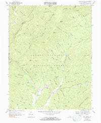
~ West Augusta VA topo map, 1:24000 scale, 7.5 X 7.5 Minute, Historical, 1967, updated 1991 Online now
Original price was: $14.95.$7.48Current price is: $7.48.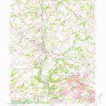
~ Collegeville PA topo map, 1:24000 scale, 7.5 X 7.5 Minute, Historical, 1966, updated 1981 For Sale
Original price was: $14.95.$7.48Current price is: $7.48.