Search Product
Our Categories
Your Cart
Your order qualifies for free shipping!
Your shopping bag is currently empty
Continue Shopping
God Particle Wargaming Mat on Sale
Original price was: $54.95.$27.48Current price is: $27.48.
Pleasant Surprise Spacebar Keycap For Discount
Original price was: $9.95.$4.98Current price is: $4.98.


God Particle Extended Mousepad Online Hot Sale
Original price was: $36.95.$18.48Current price is: $18.48.
Home Sweet Home Day Tote Online now
Original price was: $22.95.$11.48Current price is: $11.48.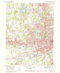
~ Canton West OH topo map, 1:24000 scale, 7.5 X 7.5 Minute, Historical, 1967, updated 1978 For Discount
Original price was: $14.95.$7.48Current price is: $7.48.
Recently Viewed
~ Timberville VA topo map, 1:24000 scale, 7.5 X 7.5 Minute, Historical, 1967, updated 1987 Online
Original price was: $14.95.$7.48Current price is: $7.48.Description
Canton West, Ohio, USGS topographic map dated 1967.
Includes geographic coordinates (latitude and longitude). This topographic map is suitable for hiking, camping, and exploring, or framing it as a wall map.
Printed on-demand using high resolution imagery, on heavy weight and acid free paper, or alternatively on a variety of synthetic materials.
Topos available on paper, Waterproof, Poly, or Tyvek. Usually shipping rolled, unless combined with other folded maps in one order.
- Product Number: USGS-5315594
- Free digital map download (high-resolution, GeoPDF): Canton West, Ohio (file size: 14 MB)
- Map Size: please refer to the dimensions of the GeoPDF map above
- Weight (paper map): ca. 55 grams
- Map Type: POD USGS Topographic Map
- Map Series: HTMC
- Map Verison: Historical
- Cell ID: 7123
- Scan ID: 224307
- Imprint Year: 1978
- Woodland Tint: Yes
- Photo Revision Year: 1978
- Aerial Photo Year: 1976
- Edit Year: 1978
- Field Check Year: 1967
- Datum: NAD27
- Map Projection: Polyconic
- Map published by United States Geological Survey
- Map Language: English
- Scanner Resolution: 600 dpi
- Map Cell Name: Canton West
- Grid size: 7.5 X 7.5 Minute
- Date on map: 1967
- Map Scale: 1:24000
- Geographical region: Ohio, United States
- Map Area ID: AREA40.87540.75-81.5-81.375
- Northwest corner Lat Long code: USGSNW40.875-81.5
- Northeast corner Lat Long code: USGSNE40.875-81.375
- Southwest corner Lat Long code: USGSSW40.75-81.5
- Southeast corner Lat Long code: USGSSE40.75-81.375
- Northern map edge Latitude: 40.875
- Southern map edge Latitude: 40.75
- Western map edge Longitude: -81.5
- Eastern map edge Longitude: -81.375
-
Neighboring Maps:
Northwest North Northeast West MAP East Southwest South Southeast All neighboring USGS topo maps are available for sale online at a variety of scales.
Spatial coverage:
Topo map Canton West, Ohio, covers the geographical area associated the following places:
– Indianola Estates – Cloverdale – Whittier Park – Terrace Mobile Park – Canton – Lakeview Terrace – Westland Park – Meyers Lake – Mount Vernon – Wexford – Lake Cable – Belvidere – Reedurban – Lakeside Heights – West Manor – Grey Ridge Estates – Plymouth Knoll – Crescent Gardens – Sweetbriar – Sun Valley Mobile Home Park – Genoa – Orchard Acres – Canton Gardens – Oak Manor – Bramblecrest – Whispering Oaks – Trailer City – Avondale – Grove Mill – Monterey Heights – Whipple Heights – Skyline Hills – Lakeview Heights – Lincoln Heights – The Knolls – South Haven Mobile Park – West Manor Mobile Home Park – Fulton Heights – Deluxe Mobile Home Park – Industrial Heights – Bishop Meadows – Colonial Hills – Harter Heights – Edgewood Park – Gambrinus – Parkridge – Melody Mobile Home Park – Edmeyer Park – Westview – Edgefield – Carie Hill Estates – Lake View Heights – Banker Heights – Ingold Heights – Augusta Lakes – Perry Heights – Sunny Acres Mobile Park – Hills and Dales – Richville – Ridgedale – Mount Marie Heights
Additional information
Print Material Regular Paper, Waterproof, Polypropylene, Tyvek
Related products
50%
~ Whaleyville VA topo map, 1:24000 scale, 7.5 X 7.5 Minute, Historical, 1967, updated 1981 Supply
Original price was: $14.95.$7.48Current price is: $7.48.50%
~ Stony Creek VA topo map, 1:24000 scale, 7.5 X 7.5 Minute, Historical, 1967, updated 1986 Online now
Original price was: $14.95.$7.48Current price is: $7.48.50%
~ Stony Creek VA topo map, 1:24000 scale, 7.5 X 7.5 Minute, Historical, 1967, updated 1968 For Sale
Original price was: $14.95.$7.48Current price is: $7.48.50%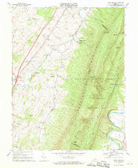
~ Tenth Legion VA topo map, 1:24000 scale, 7.5 X 7.5 Minute, Historical, 1967, updated 1970 For Discount
Original price was: $14.95.$7.48Current price is: $7.48.50%
~ Sussex VA topo map, 1:24000 scale, 7.5 X 7.5 Minute, Historical, 1967, updated 1968 Online Hot Sale
Original price was: $14.95.$7.48Current price is: $7.48.50%
~ Smith Mountain Dam VA topo map, 1:24000 scale, 7.5 X 7.5 Minute, Historical, 1967, updated 1984 Online Sale
Original price was: $14.95.$7.48Current price is: $7.48.
~ Canton West OH topo map, 1:24000 scale, 7.5 X 7.5 Minute, Historical, 1967, updated 1978 For Discount
Original price was: $14.95.$7.48Current price is: $7.48.